Downloadable Royalty Free, Editable, Digital, Perfect for Creating Sales Territory Maps
Friday, August 17, 2007
Special Editable USA Highway State Map in PowerPoint
We have many different kinds of editable maps for use in your sales and marketing presentations. A couple of our special ones are the USA Highway/City map and the USA Major Cities and Capitals map. Both of these are completely editable in PowerPoint, each state and name are unique objects that can be changed and customized.
One of the features of our US Highway map is that the highway stop at the state borders. This is great if you want to edit or color just that section of road. You can check out all of our maps at www.mapsfordesign.com
Thank you for stopping by.
USA and World Editable PowerPoint Maps Live
We continue to move forward with loading our editable powerpoint maps up on our new site. Below is the latest group. You can check them out at www.mapsfordesign.com. All of these maps are editable in PowerPoint. You just click on a state or country with your pointer and select a color from the drawing bar below and presto you can set up a sales or marketing territory
Our USA and Canada Editable PowerPoint Maps
USA with 2 Letter State Names - PowerPoint File
USA and Canada Combo Map, State, Provinces & Territories - PowerPoint File
USA with States and Names - PowerPoint File
North America, Canada, USA and Mexico Map, States and Provinces - PowerPoint File
North America Outline Map, Canada, USA, Mexico, Cities - PowerPoint File
USA 50 States, No Text - PowerPoint File
USA 50 State, Highway and Major City Map - PowerPoint File
USA 50 State, Major City and Capitals Map - PowerPoint File
USA and Mexico Map, Editable States - PowerPoint File
USA with 50 State and Capital Names - PowerPoint File
World Projection Editable Maps in PowerPoint
World Mercator Projection, Individual Editable Countries, Europe Centered - PowerPoint File
World Robinson Projection, Individual Editable Countries, Europe Centered - PowerPoint File
Sinusoidal 6 Point World Projection, Europe Centered - PowerPoint File
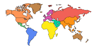
World Robinson Projection, Europe Centered, Continents - PowerPoint File
World Robinson Projection, North America Centered, Continents - PowerPoint File
World Mercator Projection, Europe Centered, Continents - PowerPoint File
World Mercator Projection, North America Centered, Continents - PowerPoint File
World Mercator Projection, Europe Centered, Continents - PowerPoint File
World Mercator Projection, Australia Centered, Continents - PowerPoint File
Sunday, August 12, 2007
Detailed USA County Maps Are Up
We have put up all of our detailed PowerPoint county maps, Alabama - Wyoming. These editable state county maps come inside of a PowerPoint slide. Each has been sized to fit nicely. Each county is an individual element that can be colored and customized. Text is all live and easy to edit. We also include an extra slide that contains the major interstate highway, water ways, capitals and major cities. This map has been sized to fit right over the county map for additional detail.
These maps are perfect for setting up sales and marketing territories, highlighting office location, or plotting out data and information. Each map sells for $39.95.
On to finishing up our USA and World Projection Powerpoint Maps.
List of our Detailed US County Maps
Maryland Editable US Detailed County and Highway Map - PowerPoint File
Virgina Editable US Detailed County and Highway Map - PowerPoint File
Texas Editable US Detailed County and Highway Map - PowerPoint File
New Jersey Editable US Detailed County and Highway Map - PowerPoint File
Alaska Editable US Detailed County and Highway Map - PowerPoint File
Alabama Editable US Detailed County and Highway Map - PowerPoint File
Arkansas Editable US Detailed County and Highway Map - PowerPoint File
Arizona Editable US Detailed County and Highway Map - PowerPoint File
California Editable US Detailed County and Highway Map - PowerPoint File
Colorado Editable US Detailed County and Highway Map - PowerPoint File
Connecticut Editable US Detailed County and Highway Map - PowerPoint File
Delaware Editable US Detailed County and Highway Map - PowerPoint File
Georgia Editable US Detailed County and Highway Map - PowerPoint File
Hawaii Editable US Detailed County and Highway Map - PowerPoint File
Iowa Editable US Detailed County and Highway Map - PowerPoint File
Idaho Editable US Detailed County and Highway Map - PowerPoint File
Illinois Editable US Detailed County and Highway Map - PowerPoint File
Indiana Editable US Detailed County and Highway Map - PowerPoint File
Kansas Editable US Detailed County and Highway Map - PowerPoint File
Kentucky Editable US Detailed County and Highway Map - PowerPoint File
Louisiana Editable US Detailed County and Highway Map - PowerPoint File
Massachusetts Editable US Detailed County and Highway Map - PowerPoint File
Maine Editable US Detailed County and Highway Map - PowerPoint File
Michigan Editable US Detailed County and Highway Map - PowerPoint File
Minnesota Editable US Detailed County and Highway Map - PowerPoint File
Missouri Editable US Detailed County and Highway Map - PowerPoint File
Mississippi Editable US Detailed County and Highway Map - PowerPoint File
Montana Editable US Detailed County and Highway Map - PowerPoint File
North Carolina Editable US Detailed County and Highway Map - PowerPoint File
North Dakota Editable US Detailed County and Highway Map - PowerPoint File
Nebraska Editable US Detailed County and Highway Map - PowerPoint File
New Hampshire Editable US Detailed County and Highway Map - PowerPoint File
New Mexico Editable US Detailed County and Highway Map - PowerPoint File
Nevada Editable US Detailed County and Highway Map - PowerPoint File
New York Editable US Detailed County and Highway Map - PowerPoint File
Ohio Editable US Detailed County and Highway Map - PowerPoint File
Oklahoma Editable US Detailed County and Highway Map - PowerPoint File
Oregon Editable US Detailed County and Highway Map - PowerPoint File
Pennsylvania Editable US Detailed County and Highway Map - PowerPoint File
Rhode Island Editable US Detailed County and Highway Map - PowerPoint File
South Carolina Editable US Detailed County and Highway Map - PowerPoint File
South Dakota Editable US Detailed County and Highway Map - PowerPoint File
Tennessee Editable US Detailed County and Highway Map - PowerPoint File
Utah Editable US Detailed County and Highway Map - PowerPoint File
Vermont Editable US Detailed County and Highway Map - PowerPoint File
Washington Editable US Detailed County and Highway Map - PowerPoint File
Wisconsin Editable US Detailed County and Highway Map - PowerPoint File
West Virgina Editable US Detailed County and Highway Map - PowerPoint File
Wyoming Editable US Detailed County and Highway Map - PowerPoint File
Florida Editable US Detailed County and Highway Map - PowerPoint File
Monday, August 6, 2007
We Have a Home Page
Yea, the home page for www.mapsfordesign is looking great. Lots of color and pictures of maps. It is looking like a real site. And with the continual addition of new maps it is pulling itself together.
Fixing Some of the Art
The process of getting the text and art correct is a huge process. Because when you work with maps, say the US State maps, if you make a change, you then have to go back and make 50 changes. The site is getting better and better. We have our detailed county maps ready to go up. That is this weeks job.
Friday, August 3, 2007
New World Projection Maps Are Up
More maps are up on Maps for Design. We continue getting our maps up. The latest group are some of our eps world continent maps. Thank you everyone for the most recent orders.
Sinusoidal 6 Point World Projection - Illustrator EPS
World Mercator Projection, Australia Centered - Illustrator EPS
World Mercator Projection 1 - Illustrator EPS
World Mercator Projection 2 - Illustrator EPS
World Mercator Projection 3 - Illustrator EPS
World Robinson Projection 2 - Illustrator EPS
World Robinson Projection 3 - Illustrator EPS
World Robinson Projection 4 - Illustrator EPS
Wednesday, August 1, 2007
World of Maps CD-ROM Clip Art Collection Currently Ready for Purchase and Download.
Loaded up and ready to go, more maps on the way. We will be loading up all of our collection of editable clip art maps over the next couple of months to our newest clip art map download site. Currently we are making thumbnails and previews, .zipping up our files and getting everything ship shape. You can also visit our other site, www.bjdesign.com where you can get a years subscription of unlimited map downloading.
Canada with Provinces & Territories - PowerPoint File
Ontario, Canada Province, Highways, Waterways, Cities - PowerPoint File
Italy, Administrative Districts, Capitals
Brazil, Administrative Districts, Capitals - PowerPoint File
Germany, Administrative Districts, Capitals, Major Cities - PowerPoint File
England, Ireland, Scotland, Northern Ireland Counties, Capitals - PowerPoint File
Sweden, Administrative Districts, Capitals, Names - PowerPoint File
North & South America Global Projection - PowerPoint File
European and African Global Projection - PowerPoint File
Mexico with States, Names, Cities - PowerPoint File
Georga Editable County Map - PowerPoint File
Kentucky Editable County Map - PowerPoint File
New Mexico Editable County Map - PowerPoint File
Maryland Editable US Enhanced County and Highway Map
Virgina Editable US Enhanced County and Highway Map - PowerPoint File
Texas Editable US Enhanced County and Highway Map - PowerPoint File
New Jersey Editable US Enhanced County and Highway Map - PowerPoint File
Florida Editable US Enhanced County and Highway Map - PowerPoint File
USA with 2 Letter State Names - PowerPoint File
USA and Canada Combo Map, State, Provinces & Territories - PowerPoint
USA with State Names - PowerPoint File
Washington State, Highways, Waterways, Cities - PowerPoint File
Maryland State, Highways, Waterways, Cities - PowerPoint File
Oregon State, Highways, Waterways, Cities - PowerPoint File
New York State, Highways, Waterways, Cities - PowerPoint File
North Carolina State, Highways, Waterways, Cities - PowerPoint File
Louisiana State, Highways, Waterways, Cities - PowerPoint File
New Hampshire State, Highways, Waterways, Cities - PowerPoint File
World Mercator Projection, Europe Centered
World Robinson Projection, Europe Centered, Individual Countries - PowerPoint File
Sinusoidal 6 Point World Projection, Europe Centered - PowerPoint File
North America Continent Map, USA, Canada, Mexico, Greenland, Iceland, Cities, Capitals - PowerPoint File
Middle East Regional Map, Countries - PowerPoint File
Europe Regional Continent Map, Countries, Capitals, Cities - PowerPoint File
Australia and Oceania Continent Map, Cities - PowerPoint File
Africa Continent Map, Countries, Names - PowerPoint File
USA with Editable States and Names, Color - Illustrator EPS
USA, Editable States with 2 Letter State Names - Illustrator EPS
Canada with Provinces & Territories – Illustrator EPS
World Mercator Projection, Europe Centered, Editable Countries - Illustrator EPS
World Robinson Projection, Europe Centered, Editable Countries - Illustrator EPS
Maps for Design Clip Art Downloadable Maps
Maps for Design offers an outstanding collection of editable, royalty free, outline clip art maps for sales and marketing presentations, illustration, graphic design and web. These are truly maps you can download and edit for all of your projects.
The collection includes: World Projections, US Maps, Canada, US States, US Counties, Canadian Provinces, World Regions and Continents, Individual Countries and Globes.
States, counties, countries and text are all individual objects and are easy to edit and customize. Maps come in PowerPoint format for presentations and Adobe Illustrator eps format for illustrations, graphic design and web development. Maps can be purchased one at a time or on CD-ROM.
• Maps for Design maps are easy to modify and use with popular page layout, presentation, and graphic/illustration programs.
• Maps are perfect for illustration, PowerPoint business sales and marketing presentations, web sites, brochures, reports, newspapers, magazines, reports, newsletters, and classroom uses.
• All electronic clip art maps are royalty free for both print and electronic uses and are available for downloaded 24 hours a day.
• Royalty free license.
• Secure ordering and download
PowerPoint Editable Maps
• PowerPoint maps are completely editable for sales and marketing presentations. Each state, county, or country is an individual element. All text is editable. Maps work with all of the drawing tools that come with PowerPoint. You can change colors, pull out sections to build regions, add stars and boxes, and customize the text. The maps are perfect for setting up sales territories.
- Each PowerPoint map comes already placed into a PowerPoint slide, just open and start to customize using the drawing tools that come with the program. Perfect for developing sales and marketing territories for your presentations.
-Every element is an individual object, including all countries, states, counties and text.
- State maps have major highways, capitals, cities, and waterways.
- US State County maps come as stand alone maps, perfect for highlighting a single state and also come as part of the national US map so that multi-state regions can be put together.
- Largest collection of editable PowerPoint maps for business presentations. World, Regions, Countries, US, Canada, States, and Counties.
- Country maps are broken down by administrative districts, and include capitals, and major cities.
- We have two World Projection maps, Mercator and Robinson, broken down by individual country. Each country can be colored to highlight it. Plus many other Projections and Globes.
- All PowerPoint maps are made up of objects that can be customized. Including the countries, states, provinces, counties, and text.
- Easy to add, change or delete text on every slide.
Adobe Illustrator EPS Maps
• Adobe Illustrator digital vector eps maps are set up in layers, allowing for easy editing and customizing. Each state, county, or country is an individual element. All text is editable. Maps work with all of the Illustrator drawing tools. You can change colors, pull out sections to build regions, add stars and boxes, and customize the text. Whatever you can do in Adobe Illustrator you can do with our maps. Our eps maps also work well with Flash.
- State maps have major highways, capitals, cities, and waterways.
- Country maps are broken down by administrative districts, and include capitals, and major cities.
- US State County maps are designed to fit together to build regional territories if needed.
- We have two World Projection maps, Mercator and Robinson, broken down by individual country. Each country can be colored to highlight it. Plus many other Projections and Globes.
- Easy to add, change or delete elements.
Subscribe to:
Posts (Atom)