Sunday, January 13, 2019

Macedonia Parliament Approves New Name to North Macedonia

Macedonia Parliament Approves New Name to North Macedonia

North Macedonia, waiting for full name approval to change.


The Macedonia parliament has approved a new name for itself, North Macedonia. It is trying to appease Greece and bring itself into NATO. The Greek parliament still needs to approve it before it is official. Macedonia is currently called Skopje, after its capital by Greece. This argument has been going on since 1991.

Read the full story at NPR.org, Macedonian Parliament Approves New Name for the Country as Demanded by Greece

Monday, July 23, 2018

Canada Powerpoint Map with Editable Provinces, Territories & Names for Creating Reports and Presentations 2


Editable PowerPoint Canada Map with Provinces and Territories

Canadian PowerPoint Map with 10 provinces and 3 territories. Each map comes with editable province names, capitals, major cities. Easy to color and edit, add text or images. Alberta, British Columbia, Manitoba, New Brunswick, Newfoundland, Labrador, North West Territories, Nova Scotia, Nunavut, Ontario, Prince Edward Island, Quebec, Saskatchewan, Yukon Territory, includes Great Lakes and other lakes.


Canada Powerpoint Map with Editable Provinces, Territories & NamesThis map is available to Download in an editable PowerPoint format from MapsForDesign.com. Easy to color, customize, add text, delete sections. To learn more of purchase a Canada map, please click MapsforDesign.com

.

Saturday, July 21, 2018

USA 2 Letter State Map in PowerPoint, Easy to Customize States and Regions


One of our most popular royalty free maps is the 2 Letter State Names USA PowerPoint Map. Fully editable. All states are individual elements that can be filled with color, enlarged, reduced, pulled out. Perfect for setting up a quick sales territory map. Each state is an individual object. Also great for home school, education and geography lessons.

USA 2 Letter, Editable State Map in PowerPoint 
This map is available to Download in an editable PowerPoint format from MapsForDesign.com. Easy to color, customize, add text, delete sections. To learn more check out MapsforDesign.com


Friday, July 20, 2018

Making Map Icons and Markers for your PowerPoint Presentations

We got a call recently on if we sold map icons or markers for PowerPoint presentations. We don't, but it got me thinking I should and it is now on the list. In the mean time I found this video that showed how easy it is to create them. I have also added this to our new Resource page here on the blog


New Map Resources Page for MapsForDesign Blog


We are please to announce our new Map Resources Page on our MapsForDesign blog. This resources includes clip art and map presentation websites, PowerPoint slide templets, icons and other resources to help you create your presentations.

Included are
• Clip art map sites for presentation, graphic design, web, education, antique and historical maps
• Flash maps for building interactive website maps
• Software for setting up sales and territories and marketing map
• Zip code maps
• Antique and historical maps resources and websites
• PowerPoint slide templates websites, including sources for icons and map markers

Click here or in the navigation in the upper right to visit.

Saturday, September 30, 2017

PDF World of Maps 5 Books Combo Package

PDF Map Pack of 5 Coloring Books, World, USA, Canada, World Globes, USA States from Bruce Jones on Vimeo.


Get All 5 PDF Map Books for the price of one! In this one Combo collection we include all 4 of our PDF Blank Outline Map Coloring Books. The collection includes: World Maps with Globes and Projections, USA and States, World Regional Maps and Canada, Provinces, Territories and Flags maps.   

Each blank, outline, printable continent map is presented with a detail version with political borders, country, capitals, major city names and country name, and then an outline map with just country names and a blank outline map without any of the information, great to color however you want. The books are great for learning world geography, coloring, home school, classroom and general education. 

The printable, blank, outline maps in this books can be freely photocopied by a teacher or parent for use in a classroom or for home school lessons.


BOOK 1 World Regional Maps PDF Coloring Book: Blank Maps, Continents, World Projections, USA and Canada
Black outline blank world maps included in the coloring book are:

World Maps – Robinson Projection, World Maps – Mercator Projection
• United States Outline Maps, with and without names, Canada Maps, with and without names

World Regional and Continent Maps:
• Africa Map, Asia Map, Australia, Oceania Map, Australia Map, Europe Map, Maps of North America including Canada, USA and Mexico, South America, Antarctica Map

Additional world regions maps included are:
• Russia Map, Central America and the Caribbean Map, Central America Map, Europe to the Ural Mountains Map, Eastern Europe Map, Eastern Europe – Baltic Region Map, Middle East Map, Mediterranean Regional Map, Latin America Map, Scandinavia Map, Southeast Asia Map


BOOK 2 USA Maps and the 50 USA States Coloring PDF Book
USA Maps and the 50 States PDF Coloring Book contains each of the 50 US states, Arizona to Wyoming.  Each outline map is presented in two ways, one page has the map with corresponding cities, capitals and physical features and the next page has the blank outline without any of the information, state facts and then each state placed in context with its surrounding states. Students can trace the outlines of the map, study and highlight cities, capitals and features, and finally review by filling in the pertinent data on the blank map.  Each state is located on a USA map and is a great resource for students.

Also included are US territories: Guam, Saipan, Northern Mariana Islands, Puerto Rico, and the United States Virgin Islands.


BOOK 3 USA State Maps Coloring Book, Includes USA, Canada and North America Blank Maps PDF Book
Same basic maps as the USA Maps and the 50 USA States book above but designed for younger students. The maps are a little simpler and with less detail. 


BOOK 4 Canada, Provinces and Territories Map PDF Coloring PDF Book
The Canada, Provinces and Territories PDF Map Coloring Book includes blank, outline and labeled maps of each Province or Territory. the detailed maps include political borders, capital, major cities and towns. Includes a variety of maps with names and other information like highways, rivers and lakes, cites and towns, and capital.

Along with each Province map is included their flag with some general information, including; Capital, Population, Size, Confederation, Motto, Bird, Flower, Tree, and a Fun Fact. 

Black outline, blank Canadian maps included in the coloring book are:

Canada and the United States, Canada, Canada Provinces and Territories: Alberta, British Columbia, Manitoba, New Brunswick, Newfoundland and Labrador, Northwest Territories, Nova Scotia, Nunavut, Ontario, Prince Edward Island, Quebec, Saskatchewan, Yukon Territory, North America, North America Globe, United States. Each Province or Territory flag is also included.


BOOK 5 World Maps and Globes PDF Coloring Book
Learn and color the basic geographic layout of the world with World Maps and Globes PDF Coloring Book. World Maps and Globes PDF Coloring Book is great for coloring, home school, learning about the world. The maps are blank, outline, un-labled maps, presented in several ways, one page with detail and the other page with a blank outline without any of the information, great to color however you want. 

Black outline blank World maps included in the book are:

World Robinson Projection Map
• World Mercator Projections Map, Sinusoidal 6 point World Projection Map, United States Map with and without state names, Canada and North America Map

Also lots of Globe maps to color: North & South America Globe Map
• Europe Globe Map, North America Globe Map, South India Ocean Globe Map, South America Globe Map, Pacific Ocean Globe Map, Middle East Globe Map, Japan & Pacific Ocean Globe Map, India & Asia Globe Map, Australia Globe Map, Africa Globe Map, North Pole Globe Map, South Pole Globe Map

The printable, blank, outline maps in this books can be freely photocopied by a teacher or parent for use in a classroom or for home school lessons. Download the Pack Today


Buy the Map Book Pack

Thursday, July 6, 2017

US County Map for Building a Sales Territory Map from Maps For Design

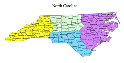
North Carolina Editable PowerPoint Map for Making a Sales Territory Map. This editable PowerPoint map is perfect for your presentations that need a county map. All of the counties are editable, you can change the colors, add text or graphics. Each element is an individual object that you can take out, or delete.  Perfect for setting up sales and marketing territory for your team. Each county is an individual object that can be colored and customized. You can change colors, pull out several counties to build regions, add a star for an office, edit the text and delete what you don't want.

To learn more about our editable maps and the North Carolina map please visit:
https://www.mapsfordesign.com/product/north-carolina-editable-us-detailed-county-and-highway-powerpoint-map/

Learn How to Color a USA State County Map to Make a Sales Territory Map from our MapsForDesign Collection


This video highlights our editable US State Detailed PowerPoint County Maps with Names, it is royalty free, easy to customize and edit, change colors, add text and build custom regions. Great for building and setting up a sales territory map. Each map has also been enlarged to fit nicely on a PowerPower slide.

In the video I show you how easy the maps are to Edit. Each country is an individual object that you can select and color. Select the county with your pointer, and fill with a new color.

To change several counties at once, hold down the shift key while you are selecting the county or click, hold the mouse button and drag around several counties. Then choose a fill color.

All text is fully editable and can be added or changed. Use the insert text box in your tool bar and add new text.

It is easy to delete counties you don’t want or grab ones that you do to build a custom map.

Because the maps are vector outlines the counties can be enlarged to reduced with no loss of sharpness, just group the counties and change the size.

You can add any of the PowerPoint objects or shapes such as a star, arrow or boxes to your map

Each map comes pre-loaded in a PowerPoint slide deck with and without text and a third slide that includes the major cites, interstates and waterways.

Maps can be shared with your team on multiple computers for no additional cost and are easy to email to anyone.

To learn more about our editable US County Detailed PowerPoint Maps please visits
https://www.mapsfordesign.com/product-category/us-counties-maps/


MapsforDesign.com
 Maps for Design is your home for editable, royalty free, easy to customize, downloadable, PowerPoint maps for sales, marketing and business presentations. Great for reports, use in education and on the web.


We have a full range of USA and Canadian maps, World Projections, US States and US Counties, Canadian provinces, World regions and countries. All easy to download for your projects.

Check us out at Maps for Design.com your home for editable downloadable, PowerPoint maps.

Maps for Design offers an outstanding collection of editable, royalty free, outline clip art maps for sales and marketing presentations, illustration, graphic design and web. These are truly maps you can download and edit for all of your projects.

PowerPoint maps are completely editable for sales and marketing presentations, Each state, county or country is an individual element that can be customized. All text is editable, Maps work with all of the drawing tools that come with PowerPoint. You can change colors, pull out sections to build regions, add stars and boxes, and customize the text. The maps are perfect for setting up sales territories, marketing and business presentations, reports and classroom projects.


Click to see samples and more about US and Canada https://www.mapsfordesign.com/free-samples/

Monday, June 5, 2017

How to Color a US/Canada Map for PowerPoint and Create a Sales and Marketiing Territory Map


This video is on our editable USA and Canada PowerPoint Combo Map with Names, it is royalty free, easy to customize and edit, change colors, add text and build custom regions. Great for building and setting up a sales territory map.

Let Me Show You How Easy the Maps are to Edit. Each state and province is an individual object that you can select and color. Select the state or province with your pointer, and fill with a new color.

To change several states at once, hold down the shift key while you are selecting the county or click, hold the mouse button and drag around several states. Then choose a fill color.

All text is fully editable and can be added or changed. Use the insert text box in your tool bar and add new text.

It is easy to delete states or provinces you don’t want or grab ones that you do to build a custom map.

Because the maps are vector outlines the states or provinces can be enlarged to reduced with no loss of sharpness, just group the states and change the size. You can also select each country.

You can add any of the PowerPoint objects or shapes such as a star, arrow or boxes to your map

Each map comes pre-loaded in a PowerPoint slide deck with and without.

Maps can be shared with your team on multiple computers for no additional cost and are easy to email to anyone

To learn more about our US and Canada maps please click the link
https://www.mapsfordesign.com/product/usa-canada-combo-powerpoint-map-editable-states-provinces-territories/

MapsforDesign.com
Maps for Design is your home for editable, royalty free, easy to customize, downloadable, PowerPoint maps for sales, marketing and business presentations. Great for reports, use in education and on the web.

We have a full range of USA and Canadian maps, World Projections, US States and US Counties, Canadian provinces, World regions and countries. All easy to download for your projects.

Check us out at Maps for Design.com your home for editable downloadable, PowerPoint Maps for Design offers an outstanding collection of editable, royalty free, outline clip art maps for sales and marketing presentations, illustration, graphic design and web. These are truly maps you can download and edit for all of your projects.

PowerPoint maps are completely editable for sales and marketing presentations, Each state, county or country is an individual element that can be customized. All text is editable, Maps work with all of the drawing tools that come with PowerPoint. You can change colors, pull out sections to build regions, add stars and boxes, and customize the text. The maps are perfect for setting up sales territories, marketing and business presentations, reports and classroom projects.

 Click to see samples and more about US and Canada map
https://www.mapsfordesign.com

USA and Canada Editable PowerPoint Map for Making a Sales and Marketing Territory Map

USA and Canada PowerPoint Editable Map


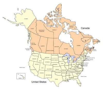
USA and Canada Editable PowerPoint Map for Making a Sales Territory Map. This editable PowerPoint map is perfect for those presentations that need a cross border map. All states and Provinces are editable, you can change the colors, add text or graphics. Each element is an individual object that you can take out, or delete.  Perfect for setting up sales and marketing territories and regions if you need both USA and Canada. Each state or province is an individual object that can be colored and customized. You can change colors, pull out states or provinces to build regions, add a star for an office, edit the text and delete what you don't want. The countries can be pulled apart, this map is a two for one combo.

To learn more about our editable maps and the US and Canada map please visit:
https://www.mapsfordesign.com/product/usa-canada-combo-powerpoint-map-editable-states-provinces-territories/


How to Color a World Projection PowerPoint Map to Make a Sales Presentation Map


Let Me Show You How Easy the Maps are to Color and Edit in this new video on our editable PowerPoint World Projection Maps. Each country in the map is an individual object that you can select and color. Select the Country with your pointer, and fill with a new color.

All text is fully editable and can be added or changed. Use the insert text box in your tool bar and add new text.

It is easy to delete an element you don’t want or grab ones that you do to build a custom map.

Because the maps are vector outlines the countries can be enlarged to reduced with no loss of sharpness, just group the countries and change the size. Right Click on your mouse or Control Click

You can add any of the PowerPoint objects or shapes such as a star, arrow or boxes to your map

Each map comes pre-loaded in a PowerPoint slide deck, you have a full map with land and text, just land, and just the text.

Maps can be shared with your team on multiple computers for no additional cost and are easy to email to anyone.

To learn more about our editable world projection PowerPoint maps please click this link:
https://www.mapsfordesign.com/product-category/world-projection-maps/ 


World Mercator Map, in PowerPoint, fully editable, ready to be customized for your presentation. Comes with and with out names.

Click here to see our World Mercator Projection PowerPoint Map with Individual Editable Countries and Names

Monday, January 16, 2017

Ireland Editable PowerPoint Map Added to the Collection

We always had our Ireland map as part of the general UK map. Recently I wondered why did I do that. So I have pulled out Ireland and it has its own product. The map is broken down by counties with the capital Dublin added. Each counties is an individual element that can be colored, pulled out and edited however you need. Perfect for your PowerPoint sales and marketing presentations, education or general map needs.

Ireland Editable PowerPoint Country Map
 To learn more or to purchase a map, please click here, Ireland Editable PowerPoint Map with Counties and Capital

Friday, November 11, 2016

USA Editable PowerPoint Map with 2 Letter State Names Our Most Popular Map

USA Editable PowerPoint Map with 2 Letter State Names Our Most Popular Map. It continues to be our base map year after year. The editable PowerPoint map has individual states with the two letter postal codes for names. Like all of our maps at MapsForDesign.com this file contains the combine land and text names slide, a slide with just the states themselves and a slide with just the names incase you happen to delete some names, you can just go grab them and put them back.

Like all of our maps they are royalty free, fully editable in PowerPoint and Apple Keynote and can be used for all kinds of presentations, including setting up a sales territory, website graphics and educations. The maps can be shared with your team and staff as needed.

  
USA editable PowerPoint map with 2 letter state names.
 Click here to learn more about the USA editable 2 letter state names PowerPoint Map

Thursday, November 10, 2016

States Along the Mississippi Getting Ready for Flooding, Mississippi, Arkansas, Louisiana, and Missouri

State of Mississippi Map, editable PowerPoint map
Click here to learn more about our PowerPoint editable Mississippi State Map https://www.mapsfordesign.com/product/mississippi-us-state-powerpoint-map-highways-waterways-capital-and-major-cities/

State of Missouri Map, editable PowerPoint map

Click here to learn more about our PowerPoint editable Missouri State Map, https://www.mapsfordesign.com/product/missouri-us-state-powerpoint-map-highways-waterways-capital-and-major-cities/


State of Arkansas Map, editable PowerPoint map
Click here to learn more about our editable PowerPoint Arkansas State Map

State of Louisiana Map, editable PowerPoint map
Click here to learn more about our PowerPoint editable Louisiana State Map

The spring water is rolling down the Mississippi on its way to the Gulf. We feel for all the folks along the path as they deal with the floods. Today's post has just some of the states along its border: Mississippi, Missouri, Arkansas, and Louisiana

New Maps For Design Website for Editable PowerPoint Maps

We are please to announce the major new upgrade to our editable PowerPoint maps website, MapsForDesign.com. Over the last year or so we have been hard at work on building a new modern website for our flagship clip-art map site. We now have a site that works on both platforms; desktop and mobile. Easier to navigate and keep up to date.


Maps For Design.com is the leading website for editable PowerPoint Maps for sales presentations, building sales territories, marketing, education.

Click here to visit our new website: https://www.mapsfordesign.com/

Saturday, August 10, 2013

Editable PowerPoint Virginia County Map

We had a nice question come in about our editable PowerPoint maps, I made up a short video answer

Question
Do the US county maps include main interstates and highways?  Can you enter more data in a specific county other than the county name?   My goal is to have a county map with county names, main highways/interstates, be able to color code the counties and add a number to each county.
Looking for a state county map with county names and main roads.

Answer
We have a nice collection of editable county maps. This short video highlights our Virginia editable county PowerPoint map and all of its features.


Our county maps include 4 slides, Land and Text, just the Land, just the Text and a fourth with the major interstates and cities. All element are editable and can be changed. You can learn more about our maps at http://www.mapsfordesign.com

Monday, June 3, 2013

USA National County Map with Editable Counties and Names for PowerPoint

View of our large 28" x 20" USA National County Map with the included PowerPoint slides.
USA National PowerPoint Editable County Map
One of our most popular editable PowerPoint maps is our USA National County Map. Available on  MapsforDesign.com site. This map is used by sales and marketing managers who want to set up a national county sales territory map with the big picture. This is a complicated map with over 3,000 counties, below are some tips for getting the most out of this map.

But we have a larger national county map that is 28" wide by 20" high. What we usually do is email this larger file to anyone who purchases the 17" x 11" map. Here is a link for the current PowerPoint USA National County map. I am going to work on getting the larger map up on MapsforDesign.com shortly.


How to Build a US National County Sales Territory Map in PowerPoint from Bruce Jones on Vimeo.

Some key tips to keep in mind when you purchase and use this map for your projects.
Grouping and UnGrouping - The county map is set up with each state's counties grouped together, and with their names set up as a group on top. Grouping and Ungrouping are very important when working with a map like this. I usually recommend that you customized one state at a time. You can pull a state out and paste it on a second slide, customize it and then put it back.

Selecting Several Counties at The Same Time - Your Shift key is your friend for grabbing several objects at the same time and setting up a sales or marketing territory. Click on the first county, push down your Shift key and then click on additional counties. Once they are selected you can add a fill color to make them all the same.

Selecting and Pulling Out Several States at The Same Time - The task is to select several states. It is usually easier with this map to delete what you don't want instead of trying to select what you do want. Once you have the surrounding states cleared out it is easy to grab the states you want.

Snap to Grid - On all of our maps the Snap to Grid has been turned off. The default in PowerPoint is that the Snap to Grid is turned on. The Snap to Grid is an invisible grid in the PowerPoint slide that helps you line objects up. What happens with our maps is if Snap to Grid is on and you pull out several counties from the big map, customize them and put them back, it can be tough to get them back all lined up from where they came out from. If the grid is off it is easy. This comes into play if you select one of our maps and paste it into another presentation the Snap to Grid will be on. To turn it off hold down the Control key on your keyboard and Right Click with your Mouse. You will see it as an option in the pop up window, just click it off.

We have put together a couple of videos on how to customize this map and set up a sales territory.
Working with a section of the map. http://www.mapsfordesign.com/video/video6.php
Setting up a Sales Territory map http://www.youtube.com/watch?v=ugOB6ZyW8ug

Thursday, October 25, 2012

Locating the Edit Points Command in PowerPoint 2010

Found an excellent tutorial from Indezine on editing points in Powerpoint 2010. The Edit Point option is always a tricky thing to do and often hard to locate in Powerpoint, they keep moving it around. But gives you the ability to customize your map http://www.indezine.com/products/powerpoint/learn/shapes/edit-points-for-shapes-in-ppt2010.html

Monday, October 22, 2012

Downloading and Sharing Our Editable Maps with Your Staff

Map Monday video question about using our maps with your staff and downloading it to multiple PCs. No problem at, we love when multiple people use our maps for their projects and we make it as easy as we can for you to do this. Our maps are in PowerPoint format and they are easy to email around however you need.

If you have a lot of offices around the country or world we also have licenses for that, but for the general work team, feel free to share. For more info please contact us or visit www.bjdesign.com

Check out our video on this topic.