We got a call recently on if we sold map icons or markers for PowerPoint presentations. We don't, but it got me thinking I should and it is now on the list. In the mean time I found this video that showed how easy it is to create them. I have also added this to our new Resource page here on the blog
Showing posts with label Powerpoint presentations. Show all posts
Showing posts with label Powerpoint presentations. Show all posts
Friday, July 20, 2018

Monday, June 5, 2017
How to Color a World Projection PowerPoint Map to Make a Sales Presentation Map
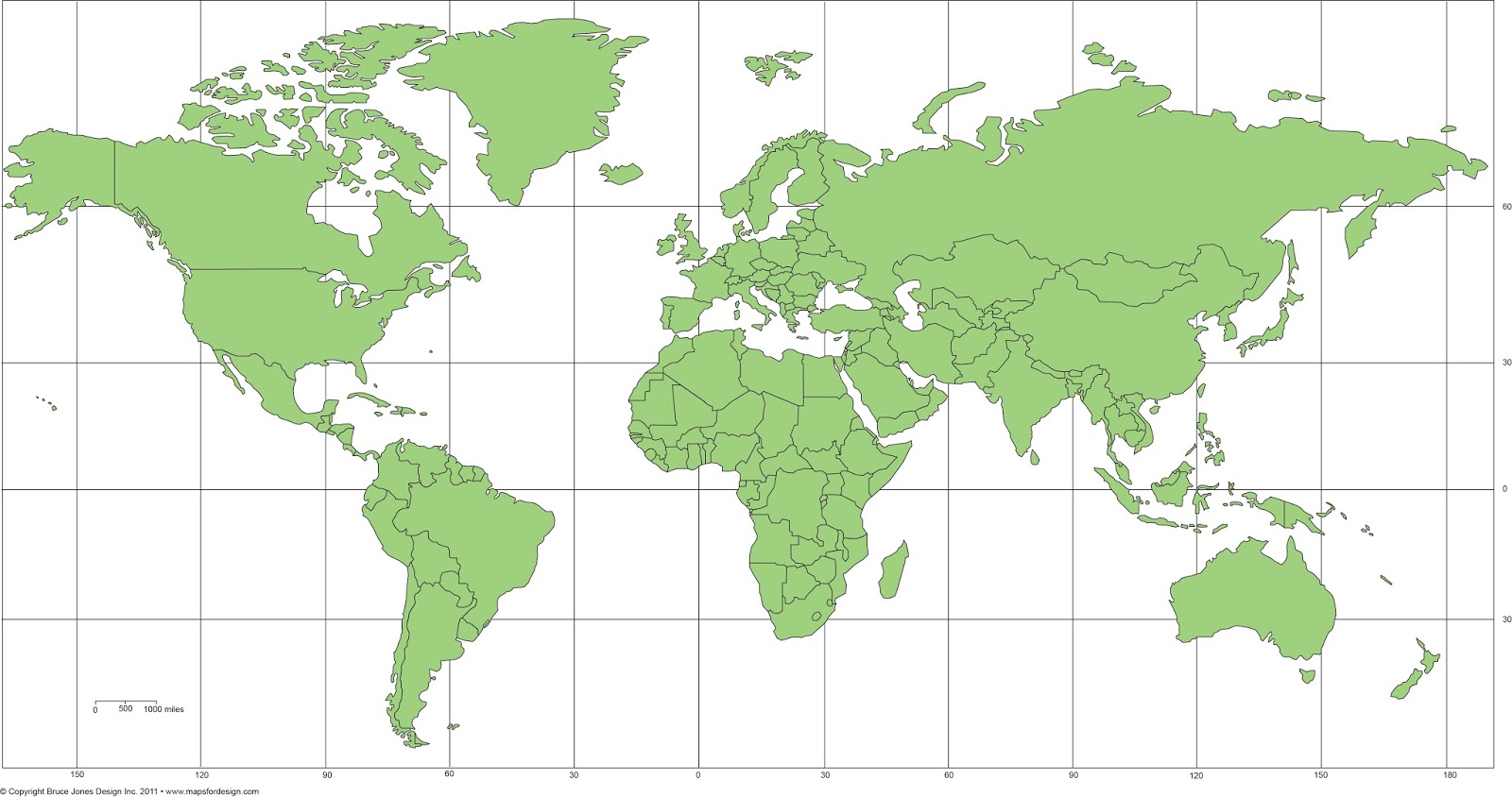
Let Me Show You How Easy the Maps are to Color and Edit in this new video on our editable PowerPoint World Projection Maps. Each country in the map is an individual object that you can select and color. Select the Country with your pointer, and fill with a new color.
All text is fully editable and can be added or changed. Use the insert text box in your tool bar and add new text.
It is easy to delete an element you don’t want or grab ones that you do to build a custom map.
Because the maps are vector outlines the countries can be enlarged to reduced with no loss of sharpness, just group the countries and change the size. Right Click on your mouse or Control Click
You can add any of the PowerPoint objects or shapes such as a star, arrow or boxes to your map
Each map comes pre-loaded in a PowerPoint slide deck, you have a full map with land and text, just land, and just the text.
Maps can be shared with your team on multiple computers for no additional cost and are easy to email to anyone.
To learn more about our editable world projection PowerPoint maps please click this link:
https://www.mapsfordesign.com/product-category/world-projection-maps/
World Mercator Map, in PowerPoint, fully editable, ready to be customized for your presentation. Comes with and with out names.
Monday, January 16, 2017
Ireland Editable PowerPoint Map Added to the Collection
We always had our Ireland map as part of the general UK map. Recently I wondered why did I do that. So I have pulled out Ireland and it has its own product. The map is broken down by counties with the capital Dublin added. Each counties is an individual element that can be colored, pulled out and edited however you need. Perfect for your PowerPoint sales and marketing presentations, education or general map needs.
To learn more or to purchase a map, please click here, Ireland Editable PowerPoint Map with Counties and Capital
 |
| Ireland Editable PowerPoint Country Map |
Thursday, October 25, 2012
Locating the Edit Points Command in PowerPoint 2010
Found an excellent tutorial from Indezine on editing points in Powerpoint 2010. The Edit Point option is always a tricky thing to do and often hard to locate in Powerpoint, they keep moving it around. But gives you the ability to customize your map
http://www.indezine.com/products/powerpoint/learn/shapes/edit-points-for-shapes-in-ppt2010.html
Monday, October 22, 2012
Downloading and Sharing Our Editable Maps with Your Staff
Map Monday video question about using our maps with your staff and downloading it to multiple PCs. No problem at, we love when multiple people use our maps for their projects and we make it as easy as we can for you to do this. Our maps are in PowerPoint format and they are easy to email around however you need.
If you have a lot of offices around the country or world we also have licenses for that, but for the general work team, feel free to share. For more info please contact us or visit www.bjdesign.com
Check out our video on this topic.
If you have a lot of offices around the country or world we also have licenses for that, but for the general work team, feel free to share. For more info please contact us or visit www.bjdesign.com
Check out our video on this topic.
Thursday, September 27, 2012
PowerPoint Russia, China, India and Southeast Asia Map
 |
| Russia, China, India, and Southeast Asia editable PowerPoint Map. |
Thursday, September 20, 2012
Australia Oceania World Regional Map
We have been highlighting some of our World Regional Maps from our World of Maps collection. Today we show our editable Australia Oceania map. We actually have several maps of this area of the world, including individual country maps, Australia, New Zealand, Philippines Indonesia and more. All maps are editable and in both PowerPoint and Adobe Illustrator. This map is available at both of our sites, www.bjdesign.com and www.mapsfordesign.com
 |
| Australia and Oceania editable map, comes in both PowerPoint and Adobe Illustrator |
Tuesday, September 18, 2012
Africa Regional World Map from our World of Maps Collection
 |
| Africa Regional World Map |
Republic of Ireland Map produced for a customer
We had a request from on of our World of Maps customers from www.bjdesign.com for a PowerPoint map of Ireland for a customer who was setting up sales territories. We have included that map in our Great Britain map all along but didn't have it as a separate map. Not sure why that happen, but sometimes things get over looked. The customer asked about an individual one, so easy enough to make up. I took the Great Britain map and deleted the UK parts and then enlarged the Ireland side, fixed the text a little and there you are. Our maps are pretty flexible and easy to change. Once done I sent the map off to the UK for the customer. We received back and very comment and I am glad to help.
Here is the comment, thank you very much, we love comments and we love finding out where we have holes in the collection. I will get this new map into the collection.
"Bruce, that's fantastic, thank you!
We use your maps every day when selling territories. Best maps we've ever bought!"
Paul
Here is the comment, thank you very much, we love comments and we love finding out where we have holes in the collection. I will get this new map into the collection.
"Bruce, that's fantastic, thank you!
We use your maps every day when selling territories. Best maps we've ever bought!"
Paul
 |
| Republic of Ireland and Northern Ireland, editable PowerPoint Map |
Monday, July 23, 2012
Map Monday Video • US National Country Map with Names in PowerPoint
It is time for our Map Monday Video so on to a question that came into our comment box, people send us all kinds of questions and we love to get them.
Today's question comes a viewers boss and the question is do you have an editable national US County PowerPoint map with all of the names listed on the map.
Answer:
So they're asking about our USA National County editable PowerPoint map. This is the map the entire national US County editable PowerPoint map. This map is in PowerPoint and it has all the counties in United States all 3120 of them and also has all of their names on it.
So lets bring that map up here in PowerPoint so you can see that. So this is a fully editable National US map of all the counties in PowerPoint, all 3120 of them in United States. So if I click on it let's say the state of Maine, lets zoom in here and I can select this state and go to my formatting palette and choose another color. We can change this orange color to say a yellow color. I still have the entire state grouped so it all changes to one color, but everything in this state is a separate editable County. The state of Maine is made up of individual county maps and I can go and ungroup it in PowerPoint and work each individual county. I go to the draw toolbar and I can just click right here and I can now see all the individual counties are separate objects. I can color each individual object and fill it with its own color.
So that's what people are asking about, that can they change these things, are they editable but what they are really looking for is are there names on all of these counties. Because this is a big map with a lot of names and a lot of counties and they wanted to go in there and find their specific County and make the changes. So yes we have a US national County map with all the usual counties and that we also have a version with names on it. The name version isn't on the site but we can send you that our version if you purchase of the regular County map. It is a pretty big file so we just email it to you rather than set up for download like all the others.
So not only can you change all the individual counties and the colors but also the text you just have to ungroup it is we have it group by state can keep it organized. Each one of those names can be change, formatted differently, deleted or moved around or whatever it is you want to do.
Here is the link for the actual map on MapsForDesign.com
http://www.mapsfordesign.com/US-National-County-Editable-County-PowerPoint-Map-for-Building-Regions.html
We have lots of customers go in and customize this map especially when they have a need for a general territory map that's crossing state lines. There are much more sophisticated maps out there that are tied to a database, we don't have that. Our map is all done by hand but it works pretty well when you need to set up a basic territory map.
We also have individual state county maps in PowerPoint.
The slide package also includes a version of the map with names, without names, on a blank map with just names, and also a state outline map that can be laid on top to give you a nice borders.
For More Information, These maps are located on both of our sites on
http://www.BJDesign.com our subscription site
http://www.Mapsfordesign.com our site for individual maps
Saturday, May 28, 2011
Editable Maps for Great Presentations
Do you have a PowerPoint presentation coming up where you need to show offices or territories, or locations on a map? Have you gone on line, pulled down a map on to discover that you can't edit it. You can't color in the states or counties or fix the text.
Well we have the solution, with our World of Maps editable PowerPoint and Adobe Illustrator maps you can build successful presentations, reports, design projects, websites. World of Maps is a collection of editable PowerPoint and Adobe Illustrator maps for building presentations, reports, graphic design, website and education. The maps are fully editable, with states, counties, countries, USA, World and continent regional maps.
Each map is fully editable, each country, county, state, is an individual object that can be colored, resized, moved around or even deleted. All text is live and can also be moved around. Perfect for making presentations, the maps come right in PowerPoint which almost everyone knows and is easy to email to your team.
Two ways to buy; a full collection or just an individual state or country.
You can learn more at www.mapsfordesign.com and www.bjdesign.com
Section: SALES
Well we have the solution, with our World of Maps editable PowerPoint and Adobe Illustrator maps you can build successful presentations, reports, design projects, websites. World of Maps is a collection of editable PowerPoint and Adobe Illustrator maps for building presentations, reports, graphic design, website and education. The maps are fully editable, with states, counties, countries, USA, World and continent regional maps.
Each map is fully editable, each country, county, state, is an individual object that can be colored, resized, moved around or even deleted. All text is live and can also be moved around. Perfect for making presentations, the maps come right in PowerPoint which almost everyone knows and is easy to email to your team.
Two ways to buy; a full collection or just an individual state or country.
You can learn more at www.mapsfordesign.com and www.bjdesign.com
Section: SALES
Saturday, October 2, 2010
Overview Video for Our Editable PowerPoint, Royalty Free Clip Art Maps for Presentations
Royalty free, downloadable, editable clip art maps, perfect for setting up sales and marketing presentations, showing sales territories, office locations, defining regions and project progress. Maps are also great for illustrations, websites, education, school projects, home schooling and scrapbooking.
Includes a full range of World maps, USA maps, 50 US States plus territory maps, 50 State County maps, Canada maps and Provinces maps, World Regional maps with editable countries, over 90 individual countries including United States maps, Canada maps, United Kingdom maps, India map, Australia map, and many more.
Each immediately downloadable states, county, or country map, is an individual element that can be easily edited, modified, customized, resized, changed, colored however you like or deleted, group or setup a custom map. All text blocks are live text that can be edited and changed. Easy to make a blank or printable maps for schoolor other projects, just remove the color. All maps come loaded right in a PowerPoint slide for easy editing and work with all the PowerPoint tools. Our editable clip art maps work with all version of PowerPoint on PCs or Macintosh, and with Apple's Keynote presentation software
You can see all of our new How to Edit our PowerPoint maps videos on our editablemaps YouTube Channel
Saturday, June 26, 2010
Sharing World of Maps Clip Art with Your Team or Group

Questions:
I was wondering, if we purchased the CD-ROM, would it be restricted to a single/private user or could it be used for business across the team/group?
Answer:
Hi Jennifer, thank you for visiting our site and for your question. You are free to use the maps across your team. We want you to be able to do your job and sharing with your coworkers is part of that. If you are going big, with lots of people and offices then we do have licenses for that, but for your regular team that you work with every day, feel free to share.
Monday, May 10, 2010
Directory of North America Maps from World of Maps

Including: the United States, Canada, Antiles-Aruba, Argentina, Bahamas, Bermuda, Bolivia, Brazil, Caribbean Islands, and the Cayman Islands. All of these maps come in both editable PowerPoint and Adobe Illustrator format. All elements can be customized for presentations, design projects, education, classroom. All are printable and by just selecting the land and removing the color you have a blank map that can be customized. See all of our editable country maps at www.bjdesign.com
Top Presentation Tips:
An occasional series on handy tips to help you with your presentations
Keep Your Fonts Simple in Your Presentation
Choose a font that is simple and easy to read. If you travel with your presentation choose a font that you know will be on all PCs like Arial, Times New Roman or Verdana, stay away from the fancy ones. One font for headlines and a second for body copy, with the type size fairly large, say 30pt, so everyone can read the slides. Give your font some contrast against the background color to help them stand out.


Friday, May 7, 2010
United Kingdom Editable Printable PowerPoint Maps

We have two United Kingdom maps. One is a general Great Britain map including Scotland, Wales, England, and Northern Ireland. This map also includes Ireland. This maps has a general breakdown of their administrative districts. We also have a much more detailed UK map showing all of the administrative districts or the counties. This map took a long time to draw and a longer time to find a source for. We ended up licensing it from the Ordinance Department in Britain. I think this department is kind of like our USGS department or something similar. But it is a cool map. Both are available at our websites.
If you are traveling to Great Britain, check out Rick Steves's Great Britain book available at Amazon. I watch his PBS travel shows all the time.
Both of these maps are available in PowerPoint and Adobe Illustrator.
Thursday, November 5, 2009
Blank Printable Canada Outline Map, no Text

Same as the map below but just without the text names. This blank, printable Canada map can be used for your personal, corporate or educational project. It is royalty free, it can't be resold or freely distributed but you can edit or copy it without any issues. This map prints out to 8.5 x 11. We have a full range of completely editable maps on our download clip art maps sites that you can check out if you need one that you can change however you need. www.bjdesign.com
We have also pull together a simple video on how to make up a blank map from one of our editable Powerpoint Maps, please see below
Sunday, March 29, 2009
World of Maps New Clip Art Map Release
World of Maps is please to release Version 8.0 or our Editable MS PowerPoint and EPS clipart maps for sales and marketing presentations, illustrations, and websites. Royalty Free, World, USA, States, County, Countries, World Regions, and Globes.
With over 90 country maps, 40 of them brand new, an updated World projection map with names and many other upgrades this is the best collection yet of our World of Maps Clip Art Collection. Each state or country is an individual element that can be customized, changed, colored however you like.
This royalty free clip art collection is perfect for sales and marketing presentations, showing sales territories, advertising, graphic design, building maps for websites.
Wednesday, July 30, 2008
Part 3: 4 Ways to Put a PowerPoint Presentation on Your Web Site
by Rebecca Leaman from http://www.wildapricot.com
Part 3 or 4
If your organization makes PowerPoint slideshows for special events, meetings and conferences, you've probably put a lot of time and effort into creating each one. Why not get extra mileage from those PowerPoint presentations by putting them onto your website or blog for others to see?
Here are four different ways to share PowerPoint files on the Web:
Publish an HTML web page
PowerPoint does let you save your presentation in HTML, as a web page, but this is far from being a satisfactory solution. When you've got the presentation saved in HTML format, just upload the files to your web space and serve it up as a new page on your site. Each slide is saved as a separate image, with its own page, so you have an entire folder of files to upload to your server.
A more serious issue with saving in HTML from the PowerPoint software is that the resulting web presentation is optimized for Internet Explorer. More often than not, it will not display properly for website visitors who are using other browsers. Free open source software may be a stronger choice in this instance. OpenOffice Impress, the PowerPoint look-alike from OpenOffice.org, lets you create a PPT presentation and slideshow from scratch, and it will also convert an existing PowerPoint presentation to HTML in a form that's compatible with a broader range of browsers.
To learn more click here
Part 3 or 4
If your organization makes PowerPoint slideshows for special events, meetings and conferences, you've probably put a lot of time and effort into creating each one. Why not get extra mileage from those PowerPoint presentations by putting them onto your website or blog for others to see?
Here are four different ways to share PowerPoint files on the Web:
Publish an HTML web page
PowerPoint does let you save your presentation in HTML, as a web page, but this is far from being a satisfactory solution. When you've got the presentation saved in HTML format, just upload the files to your web space and serve it up as a new page on your site. Each slide is saved as a separate image, with its own page, so you have an entire folder of files to upload to your server.
A more serious issue with saving in HTML from the PowerPoint software is that the resulting web presentation is optimized for Internet Explorer. More often than not, it will not display properly for website visitors who are using other browsers. Free open source software may be a stronger choice in this instance. OpenOffice Impress, the PowerPoint look-alike from OpenOffice.org, lets you create a PPT presentation and slideshow from scratch, and it will also convert an existing PowerPoint presentation to HTML in a form that's compatible with a broader range of browsers.
To learn more click here
Tuesday, July 29, 2008
Part 2: 4 Ways to Put a PowerPoint Presentation on Your Web Site
by Rebecca Leaman from http://www.wildapricot.com
Part 2 or 4
If your organization makes PowerPoint slideshows for special events, meetings and conferences, you've probably put a lot of time and effort into creating each one. Why not get extra mileage from those PowerPoint presentations by putting them onto your website or blog for others to see?
Here are four different ways to share PowerPoint files on the Web:
Get a Widget
Hands down, the easiest way to share a PowerPoint presentation on your website is through a free service like SlideShare.net. Think of it as something like YouTube for slide shows.
Upload your PPT, PPS, or even PDF files to SlideShare and they're converted into shared media. Copy a snippet of code to embed your presentation directly in your own web page (or simply link to your presentation page on SlideShare’s hosting service) and select the level of privacy you want for each file.
One notable advantage here is that viewers can choose to watch your presentation in full-screen format — a very useful feature if you have fine-detailed images or on-screen text you don't want your viewers to miss. You can even choose to sync the slideshow with an uploaded audio file to create an easy screencast. Comment and tag functions are included on the SlideShare site, so your organization might even benefit from the social networking aspect of the service.
But what if your organization would prefer to keep all your files on your own web space, rather than relying on a third-party service? No problem; there are several more options for getting PowerPoint onto the Web.
To learn more click here
Part 2 or 4
If your organization makes PowerPoint slideshows for special events, meetings and conferences, you've probably put a lot of time and effort into creating each one. Why not get extra mileage from those PowerPoint presentations by putting them onto your website or blog for others to see?
Here are four different ways to share PowerPoint files on the Web:
Get a Widget
Hands down, the easiest way to share a PowerPoint presentation on your website is through a free service like SlideShare.net. Think of it as something like YouTube for slide shows.
Upload your PPT, PPS, or even PDF files to SlideShare and they're converted into shared media. Copy a snippet of code to embed your presentation directly in your own web page (or simply link to your presentation page on SlideShare’s hosting service) and select the level of privacy you want for each file.
One notable advantage here is that viewers can choose to watch your presentation in full-screen format — a very useful feature if you have fine-detailed images or on-screen text you don't want your viewers to miss. You can even choose to sync the slideshow with an uploaded audio file to create an easy screencast. Comment and tag functions are included on the SlideShare site, so your organization might even benefit from the social networking aspect of the service.
But what if your organization would prefer to keep all your files on your own web space, rather than relying on a third-party service? No problem; there are several more options for getting PowerPoint onto the Web.
To learn more click here
Subscribe to:
Posts (Atom)