Tuesday, December 27, 2011

How Do I Download My Map?


We received a call today for a customer on our www.MapsForDesign.com site. He was buying a map PowerPoint Georgia County Map and couldn't quite figure out how to download the map and had a couple of questions on customizing it. The download link is just below the name of the map on the invoice form, but sometimes it doesn't seem to stand out and people give a call. We helped him and actually to get it there quickly I just emailed the map back to him. I received a nice email back from the customer and wanted to share it, I asked and he gave permission.

Bruce,

Very nice experience,

I was able to color code the counties, dropped the major cities andhighways right on top, Just what I wanted to do. Really appreciated you sending me the ppt. When I called, I was hoping I would get the kind of service you provided but I was also doubtful it would happen. Thank you!

Dick

I replied back,


Hi Dick, thank you very much for the follow up and the comments, I work hard at the customer service side and at making our maps useful.

thank you very much

bruce

And one final message

Sure - deserve it. I have not had a real positive experience with purchasing these kinds of services over the net. You did everything advertised and provided personal service back up. Thanks again.

Dick

We love getting calls from our customers, and we love answering questions.


Monday, December 19, 2011

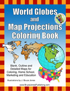
New World Globes and Map Projections Coloring Book

We have been pretty busy at map central working on some new projects. Some of them are in a new direction producing actual paper books for educations, learning and just fun. World Globes and Map Projections Coloring Book is the first of a series of Map coloring books that a based off of our map collections.

In World Globes you will learn and color the basic geographic layout of the world with World Maps and Globes Coloring Book.  World Globes is great for coloring, home school, education and even marking up a map for marketing. Blank, outline, printable maps are presented in several ways, one page with detail and the other page with a blank outline without any of the information, great to color how ever you want. Students can trace the outlines of the map, study and highlight continents and features on the blank map.  A great resource for students.

Black outline blank maps included in the book are: World Robinson Projection, World Mercator Projections, Sinusoidal 6 point World Projection, United States, Canada and North America. Also lots of Globes to color: North & South America, Europe, North America, South India Ocean, South America, Pacific Ocean, Middle East, Japan & Pacific Ocean, India & Asia, Australia, Africa, North Pole and the South Pole. 76 pages

The printable, blank, outline maps in this handbook can be freely photocopied by a teacher or parent for use in a classroom or for home school lessons.

Our book is available at Amazon.com and in a downloadable pdf.

Buy at Amazon.com

To learn more or check out the pdf version please visit, www.freeusandworldmaps.com

Sunday, December 18, 2011

Printable Blank World Projection Map

We sell lots of editable PowerPoint and Illustrator maps on our editable site, but we also have a cool free map site, www.freeusandworldmaps.com with lots of blank printable maps for all those needs when you don't need an editable map. Above is on of our Blank Printable World Maps. These are free to use for your education, personal or corporate needs.

Check out our free maps at www.freeusandworldmaps.com