Showing posts with label world of maps. Show all posts

Monday, September 24, 2012

Canada Editable Map for Presentations

Canada map with titles and individual Provinces and Territories for presentations from our World of Maps clip art collection of editable maps. This map is a fully editable PowerPoint or Adobe Illustration ready for building a presentation or customized for a classroom copy sheet. All text can be customized and the provinces can be colored.

Editable Canada Map with Provinces and Text from World of Maps Collection


Canada PowerPoint Map, Our Neighbor to the North

One of our most popular editable editable country maps is Canada. We have them in several different ways, color, black/white, combined with the USA and standing alone. All of the elements on the map can be customized, land and text. Our Canada maps are available from both of our sites, www.bjdesign.com and www.mapsfordesign.com.

Color, editable map of Canada, with provinces, no text

Map of Canada, black/white outline map with text names, each province is an individual element.

Thursday, September 20, 2012

Australia Oceania World Regional Map

We have been highlighting some of our World Regional Maps from our World of Maps collection. Today we show our editable Australia Oceania map. We actually have several maps of this area of the world, including individual country maps, Australia, New Zealand, Philippines Indonesia and more. All maps are editable and in both PowerPoint and Adobe Illustrator. This map is available at both of our sites, www.bjdesign.com and www.mapsfordesign.com

Australia and Oceania editable map, comes in both PowerPoint and Adobe Illustrator

Tuesday, September 18, 2012

Africa Regional World Map from our World of Maps Collection

Africa Regional World Map
Above is a copy of our Africa Map, one of the series of our World Regional Maps. This is an editable map, each country can be colored or changed, including taken out. All text is editable. We also have this map in Adobe Illustrator again with all countries individual objects. We have this map on both our World of Maps site, www.bjdesign.com and on www.MapsforDesign.com

Republic of Ireland Map produced for a customer

We had a request from on of our World of Maps customers from www.bjdesign.com for a PowerPoint map of Ireland for a customer who was setting up sales territories. We have included that map in our Great Britain map all along but didn't have it as a separate map. Not sure why that happen, but sometimes things get over looked. The customer asked about an individual one, so easy enough to make up. I took the Great Britain map and deleted the UK parts and then enlarged the Ireland side, fixed the text a little and there you are. Our maps are pretty flexible and easy to change. Once done I sent the map off to the UK for the customer. We received back and very comment and I am glad to help.

Here is the comment, thank you very much, we love comments and we love finding out where we have holes in the collection. I will get this new map into the collection.

"Bruce, that's fantastic, thank you!
We use your maps every day when selling territories. Best maps we've ever bought!"

Paul

Republic of Ireland and Northern Ireland, editable PowerPoint Map


Tuesday, June 14, 2011

Celebrating for Old Glory on Flag Day

Today is Flag Day, June 14, commemorating the adoption of the flag of the United States. The day was proclaimed by President Woodrow Wilson in 1916 and then made National Flag Day in August of 1949 by Congress. Fun fact, one of the longest running Flag Day parades is held every year in Quincy, MA, starting in 1952.

One of the hidden bonuses on our CD Rom collection are CIA World Fact Book maps and flags. Over 100 country's maps and flags in jpg format. Great for presentations, education and websites

Lots of Flags at Amazon (amazon affiliate links)
Annin Nyl-Glo Outdoor United States Flag - 3' x 5'

Tuesday, March 15, 2011

Searching for Where Japan is On The Globe

We have been following the events in Japan with a lot of interest and amazement. I took a quick look at our Google Analytics stats for our World of Maps site and saw a big spike on Friday, March 11, the day of the earthquake. The top 9 all centered around Japan. It was interesting to see what people were searching on and the keyword phrases they used.

In order:
  1. japan on globe
  2. where is japan on the globe
  3. globe of japan
  4. japan globe map
  5. world globe japan
  6. globe japan
  7. map of japan and usa
  8. japan globe
  9. japan on a globe

Above is our Southeast Asia map showing Japan, China and Southeast Asia, to see all of our editable PowerPoint and Adobe Illustrator maps check out http://www.bjdesign.com

Japan and Pacific Global Map

Globe map with Japan and the Pacific Ocean. Editable map in PowerPoint and Adobe Illustrator, map can be customized however you want. This map can be purchased individually and is available at http://www.mapsfordesign.com

Tuesday, February 23, 2010

Editable Europe Regional World Map, PowerPoint and Adobe Illustrator

Europe editable map from our World of Maps collection. Each country and block of text is editable and can be change in PowerPoint or Adobe Illustrator. A great map for setting up a territory for a sales region or to edit to show office locations. Countries can be pulled out and enlarged to make a special group.

Each PowerPoint map set comes with the first slide containing land and text, the second slide has just the land and the third has all of your text in case you delete some by mistake. Make sure you check out all of our How to Edit Video located on or sites. To see all of our maps on our subscription site check out www.bjdesign.com

Saturday, June 6, 2009


http://www.bjdesign.com, Join us on a tour of our World of Maps Clip Art Site our downloadable subscription map site. World of Maps at www.bjdesign is a collection of royalty free, Editable MS PowerPoint and Adobe Illustrator clipart maps for sales and marketing presentations, illustrations, graphic design, education and websites. This large collection of easy to download clip art contains editable maps of the World, USA, States, County, Countries, World Regions, and Globes.

With over 90 country maps, detailed US County maps, US State Maps, World Projections, Globes, and World Regions, you have one of the best collections for building your presentations. Remember in all of our editable PowerPoint and Illustrator state or country that each element is an individual object that can be customized, changed, colored however you like. The maps are easy to customize and change. We also include jpg copies of each map in color and black/white outline. Plus a very extensive FAQ section with how to tips and videos for customizing our maps, describing how to color, add text, enlarge or reduce, build territories and more.

Our editable royalty free clip art maps are perfect for sales and marketing presentations, showing sales territories, advertising, graphic design, building maps for websites, anywhere a royalty free map is needed

Thursday, April 23, 2009

USA and Canada Editable PowerPoint and Illustrator Maps

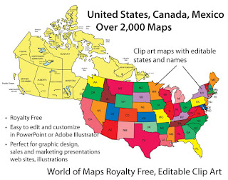
We offer a great collection of editable USA and Canadian maps. All maps are royalty free and fully editable in either PowerPoint or Adobe Illustrator, on our CD Rom or on www.bjdesign.com we also have jpg color and black and white versions of all the maps. All of the states, provinces and text are editable and can be changed, colored, moved around or even removed. Maps can be purchased on by subscription on www.bjdesign.com, or individually on www.mapsfordesign.com and at both you can pick up a CD-Rom.

Sunday, April 19, 2009

Top 10 PowerPoint Maps in a Special Promotion


We have a special promotion going on where you can purchase for one price the Top 10 PowerPoint maps that we sell. PLUS this package also includes a FREE copy of our entire World of Maps Collection CD-Rom with over 2,000 maps in PowerPoint, Adobe Illustrator and jpg formats. Yes this is our regular CD collection that we are offering with this special promotion. Also included on the disc is our new publication "How to Customize PowerPoint Clip Art Maps." The PowerPoint Top 10 map package you download right away so you can start working on your project, the CD will be mailed to you by US Priority Mail, shipping is free anywhere.

All map elements are royalty free and editable including the States, Countries and Text Names. This package includes our most popular maps. The special download PowerPoint package includes:
• USA with 2 Letter State Names
• USA with Full State Names
• USA and Canada
• USA Major Highways
• USA Major Cities, Capitals
• Canada
• Europe
• North America/USA/Canada/Mexico
• World Mercator with Countries & Names
• World Robinson with Countries

To learn more and see what is included click and jump over to our Special Top 10 PowerPoint Maps Promotion page on the MapsForDesign.com site.

Monday, April 13, 2009

Adding Multiple Cities to a USA or World Map

Customer Question: I have a subscription to your editable World of Maps collection and I work with the US State and the World Country maps a lot. One of the challenges I have is adding cities in geographically correct locations – especially as it relates to a country. It is a tedious process, do you have any ideas or methods to help me do it quicker.

Answer: Great question, one of the ideas we had when building our maps was to keep them pretty simple, to make them basic outline maps that are easy to customize for the wide variety of uses people have. Our maps aren’t set up with any database abilities but PowerPoint or Adobe Illustrator are powerful programs and you can add whatever you need.

The basic way to do would be to find a regular State or Country map that already has the cities you are looking for on it. The best place to find this is Google Maps or Google Images. Google Images is one of the navigation button on the main Google screen, you can search on the map in question. Hundreds will come up. I look for a map that is 50K or more in size and save it to my computer.

This map is then brought into PowerPoint or Illustrator using the Insert or Place commands and is sized and turned to approximately fit the outline of your existing state. You are basically use the image from Google as a template to locate your cities. You can use the shapes or drawing tools to draw small city dots and you can place them over the cities on the map graphic. Add city names, when finished delete the state or country graphic. Once you get the hang of it the process moves pretty quickly.

Don't forget, blog readers get a special 20% discount on our Maps for Design editable PowerPoint and Illustrator maps, any number of maps, any item, including the CDs, simply enter the coupon code: "MapBlog" during checkout to receive. Discount good till 12/31/2009.

Sunday, March 29, 2009

World of Maps New Clip Art Map Release


World of Maps is please to release Version 8.0 or our Editable MS PowerPoint and EPS clipart maps for sales and marketing presentations, illustrations, and websites. Royalty Free, World, USA, States, County, Countries, World Regions, and Globes.

With over 90 country maps, 40 of them brand new, an updated World projection map with names and many other upgrades this is the best collection yet of our World of Maps Clip Art Collection. Each state or country is an individual element that can be customized, changed, colored however you like.

This royalty free clip art collection is perfect for sales and marketing presentations, showing sales territories, advertising, graphic design, building maps for websites.