Monday, December 31, 2007

Quite the Winter for Colorado Travelers


As reported by the Associated Press today about 2000 travelers are stranded along I-70 in Colorado in Red Cross shelters because of a threat of avalanches closeing the highway. With winds approaching 70 miles an hours snow has drifted in to about two dozen ravines in the mountains along the road, in what is called avalanches chutes. Crews were planning to use low-power explosives on the snow to try opening up the highway. Quite a way to start the year off.

Monday, December 24, 2007

Nigeria Map Added to the Collection


We just finished drawing Nigera and have added it to our collection. Nigeria is located on the western side of Africa and gets us started working on a new continent.

Tuesday, December 4, 2007

World Maps with Names Improved


One of our popular world maps is our Mercator World Projection with Names. We have just updated this map to make it easier to use. Each country has been colored to make it easier to find and change. As with all of our PowerPoint maps each country or state is an individual element that can be changed or customized. Also all of our type is live and can be edited, moved or deleted. Great for presentations and for assigning territories the MapsforDesign collection is an effective tool for your next project.

Keep Up to Date with New Russia PowerPoint and EPS Map


We have completed several new maps recently which we are excited about. One of our newest is a map of Russia. We have been wanting to do this map for a long time but had just to many other projects going on. Now complete, the new map is available in PowerPoint and EPS for Adobe Illustrator. Both maps contain the Russian administrative districts and are completely editable with all elements objects and all type live.
The PowerPoint maps contains both just a map of the country and a map with the surrounding countries. This is great for setting up your next presentation.

Wednesday, November 7, 2007

New Country Maps on Maps for Design


We have just completed 9 new European country maps in PowerPoint and Adobe Illustrator eps formats. Each country is broken down by administrative district and includes capitals and names. Included in our new countries are, Austria, Slovenia, Lithuania, Latvia, Romania, Hungary, Bulgaria, Estonia, and Slovakia. All in color and all fully editable. To check them out click over to Maps for Design and click on the World Country link or search.

Monday, October 29, 2007

US National County Map


All of Our State, County, Globe and Canada Maps are Up

We have completed pushing up all our eps maps. All done. Today we finished loading up the eps state, state county, world globes and our Canadian province maps. Lots of maps to choose from.

With our new site we will now be able to launch new maps as we complete them. Stay tune for some more European countries. But overall our collections in a single download model are up and ready to go.

And remember that all of our maps are completely editable, including the counties, states, countries, and text. All text is live and easy to edit.

Wednesday, October 3, 2007

Adobe Illustrator EPS USA Maps


We've been busy of the last couple of weeks getting more of our maps loaded up on the site. PowerPoint maps are done and now we are moving on the the Adobe Illustrator eps maps. The World projections maps are up, including, Mercator and Robinson projections, plus many more. All editable and compatible with Flash.
The past weekend we put up the USA maps, including USA with all states, USA with Canada or Mexico, plus a couple of North America/USA, Canada, Mexico maps.
All maps are in color and are editable, text is live and can be edited. All of our eps maps are compatible with Flash.

World Projection Maps with Country Names


Newest map to our collection is a updated World Mercator Projection map with editable countries and names. Now you can set up your world wide presentations with the names of all of the major countries. Text is live, countries are individual elements that can be colored or edited as need be. In PowerPoint ready to go.

Friday, September 28, 2007

Burma in Southeast Asia

A Crisis in Myanmar/Burma


The world is watching what is going on in YANGON, Myanmar/Burma. Above are some maps from the CIA on the region. These maps are also included in our www.mapsfordesign.com World of Maps PLUS CD-ROM disc that is available in the map store on the site.

They are also available for download at the University of Texas Perry-Castaneda Library Map Collection. A great place for reference maps.

Sunday, September 23, 2007

PowerPoint Collection Complete and Loaded Up


We have finished loading up the balance of our editable PowerPoint clip art maps for presentations, illustrations and web sites.

Our Globe Maps which are in Color with Grid Lines and are Editable PowerPoint Files. Each file includes the global map inserted into a PowerPoint slide, all elements can be easily deleted or changed. You can add a star for an office location, change colors.

Africa, Global Projection
Australia, Global Projection
Europe and Africa, Global Projection
India Asia, Global Projection
Japan Pacific, Global Projection
Middle East, Africa, India, Central Asia
North America, USA, Global Projection
North Atlantic Ocean, Global Projection
North Pole, Global Projection, Grid Lines
North and South America, Global Projection
Pacific Ocean, Global Projection
South America Global Projection
India, Africa, South East Asia
South Pole, Global Projection

US Regional County Maps Posted for Download


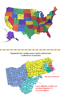
We have also completed our US Regional County Maps. The regional maps can be fitted together to form a sales territory. Completely editable with county names.

We have also included our National county map. This is the big mother map with over 3000 counties in it. Yes we do have customers that use this map and do edit all of these counties. Along with that is the same map but it has be cut up into 7 regional areas of the US and placed into a standard PowerPoint document. A little easier to manage.

Our States
US County Regional, Editable County Maps for Building Regions - PowerPoint File
US National County, Editable County Map for Building Regions - PowerPoint File
Alabama, Editable County Map for Building Regions - PowerPoint File
Alaska, Editable County Map for Building Regions - PowerPoint File
Arizona, Editable County Map for Building Regions - PowerPoint File
Arkansas, Editable County Map for Building Regions - PowerPoint File
California, Editable County Map for Building Regions - PowerPoint File
Colorado, Editable County Map for Building Regions - PowerPoint File
Connecticut, Editable County Map for Building Regions - PowerPoint File
Delaware, Editable County Map for Building Regions - PowerPoint File
Florida, Editable County Map for Building Regions - PowerPoint File
Georgia, Editable County Map for Building Regions - PowerPoint File
Hawaii, Editable County Map for Building Regions - PowerPoint File
Idaho, Editable County Map for Building Regions - PowerPoint File
Illinois, Editable County Map for Building Regions - PowerPoint File
Indiana, Editable County Map for Building Regions - PowerPoint File
Iowa, Editable County Map for Building Regions - PowerPoint File
Kansas, Editable County Map for Building Regions - PowerPoint File
Kentucky, Editable County Map for Building Regions - PowerPoint File
Louisiana, Editable County Map for Building Regions - PowerPoint File
Maine, Editable County Map for Building Regions - PowerPoint File
Maryland, Editable County Map for Building Regions - PowerPoint File
Massachusetts, Editable County Map for Building Regions - PowerPoint File
Michigan, Editable County Map for Building Regions - PowerPoint File
Minnesota, Editable County Map for Building Regions - PowerPoint File
Mississippi, Editable County Map for Building Regions - PowerPoint File
Missouri, Editable County Map for Building Regions - PowerPoint File
Montana, Editable County Map for Building Regions - PowerPoint File
North Carolina, Editable County Map for Building Regions - PowerPoint File
North Dakota, Editable County Map for Building Regions - PowerPoint File
Nebraska, Editable County Map for Building Regions - PowerPoint File
Nevada, Editable County Map for Building Regions - PowerPoint File
New Jersey, Editable County Map for Building Regions - PowerPoint File
New Mexico, Editable County Map for Building Regions - PowerPoint File
New York, Editable County Map for Building Regions - PowerPoint File
New Hampshire, Editable County Map for Building Regions - PowerPoint File
New Mexico, Editable County Map for Building Regions - PowerPoint File
Ohio, Editable County Map for Building Regions - PowerPoint File
Oklahoma, Editable County Map for Building Regions - PowerPoint File
Oregon, Editable County Map for Building Regions - PowerPoint File
Pennsylvania, Editable County Map for Building Regions - PowerPoint File
Rhode Island, Editable County Map for Building Regions - PowerPoint File
South Carolina, Editable County Map for Building Regions - PowerPoint File
South Dakota, Editable County Map for Building Regions - PowerPoint File
Tennessee, Editable County Map for Building Regions - PowerPoint File
Texas, Editable County Map for Building Regions - PowerPoint File
Utah, Editable County Map for Building Regions - PowerPoint File
Vermont, Editable County Map for Building Regions - PowerPoint File
Virgina, Editable County Map for Building Regions - PowerPoint File
Washington, Editable County Map for Building Regions - PowerPoint File
West Virgina, Editable County Map for Building Regions - PowerPoint File
Wisconsin, Editable County Map for Building Regions - PowerPoint File
Wyoming, Editable County Map for Building Regions - PowerPoint File

Wednesday, September 19, 2007

Google Documents Presentation Released

Google announced today Google Docs presentations. The new presentations feature of Google Docs helps you to easily organize, share, present, and collaborate on presentations, using only a web browser.

Starting today, presentations -- whether imported from existing files or created using the new slide editor -- are listed alongside documents and spreadsheets in the Google Docs document list. They can be edited, shared, and published using the familiar Google Docs interface, with several collaborators working on a slide deck simultaneously, in real time. When it's time to present, participants can simply click a link to follow along as the presenter takes the audience through the slideshow. Participants are connected through Google Talk and can chat about the presentation as they're watching. Not wanting anyone to feel left out, we've made the presentation feature available in 25 languages; Google Apps customers can also access it as part of Google Docs.

Check it out at http://documents.google.com

And to go along with your presentation are our maps. MapsforDesign.com editable PowerPoint maps also work very smoothly with the new Google Docs Presentation. Edit your map on your computer and then load it up onto Google Docs Presenation.


Thursday, September 13, 2007

Not Every Customer Works Out But We Love to Help

We had a customer over the last couple of days from Thailand who eventually we figured out was looking for a wall map and not an electronic map. But because of time difference, language and just not sure what they were looking for we sold them a CD-ROM of our maps. We had emails, missed phone calls in the middle of the night, everything. We finally connected today and were able to figure out what the customer wanted. We refunded the CD and gave them as much info as we could figure out of where to go. Suggesting looking for maps from our competitors, from sites in Australia, Singapore, and Thailand. It truly is a global world. Customers come from all over and we are glad to pick up the phone and just talk. All in the day of a global web based business. Sometimes the world is really pretty small.

"Hello Bruce Jones,

Thank you very much for your good support and suggestion. I’m really sorry to make you lose time.
If I have any job that concern about your software, I happy to contact you and buy your software again."
Brake&Fuel Cost Analyst Asia Pacific
TI Automotive (Thailand) Ltd.

Sunday, September 9, 2007

US States and Canada Provinces Clip Art Ready for Downloading

Hi, all, we have been working like dogs and progress has been great. This weekend we loaded up our US States and the Canadian Provinces. Almost done loading up the PowerPoint maps, I think just Globes to go and oh yea some US County maps that can be fitted together to form regions. Then on to our Adobe Illustrator Maps. Check out our MapsforDesign Line Card for the full collection.

Download Line Card

back soon, bruce

ps. remember lots of great editable world, us, states, counties and world country maps, in PowerPoint, ready for your projects.

Tuesday, September 4, 2007

United Kingdom in All Its Detail


One of our favorite PowerPoint maps is our United Kingdom map. This map which includes England, Wales, Northern Ireland and Scotland is broken down by administrative districts. To get this map we had to contact and license it from Great Britain's Ordnance Survey (OS). I think they are kind of like our US Geological Survey with some Copyright Office thrown in. This map took a long time to draw and I think it ended up pretty well. I enjoy working on these complex map, I often image myself in the areas that I am drawing.

This map is broken down by administrative districts includes surrounding countries, in color with district names and capitals, editable objects. Very detailed map for building sales and marketing territories and regions.

Like all of our maps the administrative districts are individual objects that can be colored and changed so you can build a regional territory map. Add a star for an office, change colors, edit text, pull out sections to highlight a region.

Each map comes already placed into a PowerPoint slide ready for customizing. Names, color, fully editable, PowerPoint map.
bruce

New Editable PowerPoint Country Maps

Hooray!, we have lots of new maps up on the site. We have loaded all of our editable PowerPoint Country Maps, 37 in all. Including 3 of which are written in Chinese. Like all of our PowerPoint maps, each country or administrative district is an individual object that can be colored or changed however you like. Text is fully editable. These map are great for setting up sales territories. Check them all out at www.mapsfordesign.com

Italy, Administrative Districts, Capitals - PowerPoint File
Brazil, Administrative Districts, Capitals - PowerPoint File
Germany, Administrative Districts, Capitals, Major Cities - PowerPoint File
England, Ireland, Scotland, Northern Ireland Counties, Capitals - PowerPoint File
Sweden, Administrative Districts, Capitals - PowerPoint File
Argentina, Administrative Districts, Capitals - PowerPoint File
Australia, Administrative Districts, Capitals - PowerPoint File
Belgium and Luxembourg, Administrative Districts, Capitals - PowerPoint File
China, Administrative Districts - PowerPoint File
China 2, Administrative Districts, Capitals - PowerPoint File
China with Chinese Names, Administrative Districts - PowerPoint File
Commonwealth of Independent States, Administrative Districts, Capitals - PowerPoint File
Costa Rica, Administrative Districts, Capitals - PowerPoint File
Czech Republic, Administrative Districts, Capitals - PowerPoint File
Denmark, Administrative Districts, Capitals - PowerPoint File
Finland, Administrative Districts, Capitals - PowerPoint File
France, Administrative Districts, Capitals - PowerPoint File
Greece, Administrative Districts, Capitals - PowerPoint File
India, Administrative Districts, Capitals - PowerPoint File
Indonesia, Administrative Districts, Capitals - PowerPoint File
Israel, Administrative Districts, Capitals - PowerPoint File
Japan, Administrative Districts, Capitals - PowerPoint File
Mexico, Administrative Districts, Capitals - PowerPoint File
Netherlands, Administrative Districts, Capitals - PowerPoint File
New Zealand, Administrative Districts, Capitals - PowerPoint File
Norway, Administrative Districts, Capitals - PowerPoint File
Philippines, Administrative Districts, Capitals - PowerPoint File
Poland, Administrative Districts, Capitals - PowerPoint File
South Africa, Administrative Districts, Capitals - PowerPoint File
South Korea Administrative Districts, Capitals - PowerPoint File
Spain and Portugal, Administrative Districts, Capitals - PowerPoint File
Switzerland, Administrative Districts, Capitals - PowerPoint File
Taiwan, Administrative Districts, Capitals - PowerPoint File
Turkey, Administrative Districts, Capitals - PowerPoint File
United Kingdom, Scotland, Wales, Northern Ireland, Administrative Districts, Capitals - PowerPoint File
United Arab Emirates, Administrative Districts, Capitals - PowerPoint File
USA Map with Chinese Names - PowerPoint File

20 World Regional Editable Maps.

You have the world covered with this great collection of world regional maps. Perfect for highlighting your operations especially when you can add a country map to tell your story.

North America Regional Map, USA, Canada, Mexico, Greenland, Iceland, Cities, Capitals - PowerPoint File
Middle East Regional Map, Countries - PowerPoint File
Europe Regional Map, Countries, Names - PowerPoint File
Australia and Oceania Regional Map, Cities - PowerPoint File
Africa Continent Map, Countries, Names - PowerPoint File
Antarctica Continental Map, Countries, Names - PowerPoint File
Asia Regional Map, Countries, Names - PowerPoint File
Central America Regional Map, Countries, Names - PowerPoint File
Central America Regional Map #2, Countries, Names - PowerPoint File
CIS and Asia Regional Map, Countries, Names - PowerPoint File
Commonwealth of Independent States Regional Map, Countries, Names - PowerPoint File
Eastern European Regional Map, Countries, Names - PowerPoint File
European Regional Map with Chinese Names, Countries, Names - PowerPoint File
Israel and Middle East Regional Map, Countries, Names - PowerPoint File
Latin America Regional Map, Countries, Names - PowerPoint File
Mediterranean Regional Map, Countries, Names - PowerPoint File
Scandinavia Regional Map, Countries, Names - PowerPoint File
South America Regional Continent Map, Countries, Names - PowerPoint File
South East Asia Regional Map, Countries, Names - PowerPoint File
Former Yugoslavia Region Map, Countries, Names - PowerPoint File

Friday, August 17, 2007

Special Editable USA Highway State Map in PowerPoint


We have many different kinds of editable maps for use in your sales and marketing presentations. A couple of our special ones are the USA Highway/City map and the USA Major Cities and Capitals map. Both of these are completely editable in PowerPoint, each state and name are unique objects that can be changed and customized.

One of the features of our US Highway map is that the highway stop at the state borders. This is great if you want to edit or color just that section of road. You can check out all of our maps at www.mapsfordesign.com

Thank you for stopping by.

USA and World Editable PowerPoint Maps Live


We continue to move forward with loading our editable powerpoint maps up on our new site. Below is the latest group. You can check them out at www.mapsfordesign.com. All of these maps are editable in PowerPoint. You just click on a state or country with your pointer and select a color from the drawing bar below and presto you can set up a sales or marketing territory

Our USA and Canada Editable PowerPoint Maps
USA with 2 Letter State Names - PowerPoint File
USA and Canada Combo Map, State, Provinces & Territories - PowerPoint File
USA with States and Names - PowerPoint File
North America, Canada, USA and Mexico Map, States and Provinces - PowerPoint File
North America Outline Map, Canada, USA, Mexico, Cities - PowerPoint File
USA 50 States, No Text - PowerPoint File
USA 50 State, Highway and Major City Map - PowerPoint File
USA 50 State, Major City and Capitals Map - PowerPoint File
USA and Mexico Map, Editable States - PowerPoint File
USA with 50 State and Capital Names - PowerPoint File

World Projection Editable Maps in PowerPoint
World Mercator Projection, Individual Editable Countries, Europe Centered - PowerPoint File
World Robinson Projection, Individual Editable Countries, Europe Centered - PowerPoint File
Sinusoidal 6 Point World Projection, Europe Centered - PowerPoint File
World Robinson Projection, Europe Centered, Continents - PowerPoint File
World Robinson Projection, North America Centered, Continents - PowerPoint File
World Mercator Projection, Europe Centered, Continents - PowerPoint File
World Mercator Projection, North America Centered, Continents - PowerPoint File
World Mercator Projection, Europe Centered, Continents - PowerPoint File
World Mercator Projection, Australia Centered, Continents - PowerPoint File

Sunday, August 12, 2007

Detailed USA County Maps Are Up


We have put up all of our detailed PowerPoint county maps, Alabama - Wyoming. These editable state county maps come inside of a PowerPoint slide. Each has been sized to fit nicely. Each county is an individual element that can be colored and customized. Text is all live and easy to edit. We also include an extra slide that contains the major interstate highway, water ways, capitals and major cities. This map has been sized to fit right over the county map for additional detail.

These maps are perfect for setting up sales and marketing territories, highlighting office location, or plotting out data and information. Each map sells for $39.95.

On to finishing up our USA and World Projection Powerpoint Maps.

List of our Detailed US County Maps
Maryland Editable US Detailed County and Highway Map - PowerPoint File
Virgina Editable US Detailed County and Highway Map - PowerPoint File
Texas Editable US Detailed County and Highway Map - PowerPoint File
New Jersey Editable US Detailed County and Highway Map - PowerPoint File
Alaska Editable US Detailed County and Highway Map - PowerPoint File
Alabama Editable US Detailed County and Highway Map - PowerPoint File
Arkansas Editable US Detailed County and Highway Map - PowerPoint File
Arizona Editable US Detailed County and Highway Map - PowerPoint File
California Editable US Detailed County and Highway Map - PowerPoint File
Colorado Editable US Detailed County and Highway Map - PowerPoint File
Connecticut Editable US Detailed County and Highway Map - PowerPoint File
Delaware Editable US Detailed County and Highway Map - PowerPoint File
Georgia Editable US Detailed County and Highway Map - PowerPoint File
Hawaii Editable US Detailed County and Highway Map - PowerPoint File
Iowa Editable US Detailed County and Highway Map - PowerPoint File
Idaho Editable US Detailed County and Highway Map - PowerPoint File
Illinois Editable US Detailed County and Highway Map - PowerPoint File
Indiana Editable US Detailed County and Highway Map - PowerPoint File
Kansas Editable US Detailed County and Highway Map - PowerPoint File
Kentucky Editable US Detailed County and Highway Map - PowerPoint File
Louisiana Editable US Detailed County and Highway Map - PowerPoint File
Massachusetts Editable US Detailed County and Highway Map - PowerPoint File
Maine Editable US Detailed County and Highway Map - PowerPoint File
Michigan Editable US Detailed County and Highway Map - PowerPoint File
Minnesota Editable US Detailed County and Highway Map - PowerPoint File
Missouri Editable US Detailed County and Highway Map - PowerPoint File
Mississippi Editable US Detailed County and Highway Map - PowerPoint File
Montana Editable US Detailed County and Highway Map - PowerPoint File
North Carolina Editable US Detailed County and Highway Map - PowerPoint File
North Dakota Editable US Detailed County and Highway Map - PowerPoint File
Nebraska Editable US Detailed County and Highway Map - PowerPoint File
New Hampshire Editable US Detailed County and Highway Map - PowerPoint File
New Mexico Editable US Detailed County and Highway Map - PowerPoint File
Nevada Editable US Detailed County and Highway Map - PowerPoint File
New York Editable US Detailed County and Highway Map - PowerPoint File
Ohio Editable US Detailed County and Highway Map - PowerPoint File
Oklahoma Editable US Detailed County and Highway Map - PowerPoint File
Oregon Editable US Detailed County and Highway Map - PowerPoint File
Pennsylvania Editable US Detailed County and Highway Map - PowerPoint File
Rhode Island Editable US Detailed County and Highway Map - PowerPoint File
South Carolina Editable US Detailed County and Highway Map - PowerPoint File
South Dakota Editable US Detailed County and Highway Map - PowerPoint File
Tennessee Editable US Detailed County and Highway Map - PowerPoint File
Utah Editable US Detailed County and Highway Map - PowerPoint File
Vermont Editable US Detailed County and Highway Map - PowerPoint File
Washington Editable US Detailed County and Highway Map - PowerPoint File
Wisconsin Editable US Detailed County and Highway Map - PowerPoint File
West Virgina Editable US Detailed County and Highway Map - PowerPoint File
Wyoming Editable US Detailed County and Highway Map - PowerPoint File
Florida Editable US Detailed County and Highway Map - PowerPoint File

Monday, August 6, 2007

We Have a Home Page


Yea, the home page for www.mapsfordesign is looking great. Lots of color and pictures of maps. It is looking like a real site. And with the continual addition of new maps it is pulling itself together.

Fixing Some of the Art

The process of getting the text and art correct is a huge process. Because when you work with maps, say the US State maps, if you make a change, you then have to go back and make 50 changes. The site is getting better and better. We have our detailed county maps ready to go up. That is this weeks job.

Friday, August 3, 2007

New World Projection Maps Are Up


More maps are up on Maps for Design. We continue getting our maps up. The latest group are some of our eps world continent maps. Thank you everyone for the most recent orders.

Sinusoidal 6 Point World Projection - Illustrator EPS
World Mercator Projection, Australia Centered - Illustrator EPS
World Mercator Projection 1 - Illustrator EPS
World Mercator Projection 2 - Illustrator EPS
World Mercator Projection 3 - Illustrator EPS
World Robinson Projection 2 - Illustrator EPS
World Robinson Projection 3 - Illustrator EPS
World Robinson Projection 4 - Illustrator EPS

Wednesday, August 1, 2007

World of Maps CD-ROM Clip Art Collection Currently Ready for Purchase and Download.

Loaded up and ready to go, more maps on the way. We will be loading up all of our collection of editable clip art maps over the next couple of months to our newest clip art map download site. Currently we are making thumbnails and previews, .zipping up our files and getting everything ship shape. You can also visit our other site, www.bjdesign.com where you can get a years subscription of unlimited map downloading.

Canada with Provinces & Territories - PowerPoint File
Ontario, Canada Province, Highways, Waterways, Cities - PowerPoint File
Italy, Administrative Districts, Capitals
Brazil, Administrative Districts, Capitals - PowerPoint File
Germany, Administrative Districts, Capitals, Major Cities - PowerPoint File
England, Ireland, Scotland, Northern Ireland Counties, Capitals - PowerPoint File
Sweden, Administrative Districts, Capitals, Names - PowerPoint File
North & South America Global Projection - PowerPoint File
European and African Global Projection - PowerPoint File
Mexico with States, Names, Cities - PowerPoint File
Georga Editable County Map - PowerPoint File
Kentucky Editable County Map - PowerPoint File
New Mexico Editable County Map - PowerPoint File
Maryland Editable US Enhanced County and Highway Map
Virgina Editable US Enhanced County and Highway Map - PowerPoint File
Texas Editable US Enhanced County and Highway Map - PowerPoint File
New Jersey Editable US Enhanced County and Highway Map - PowerPoint File
Florida Editable US Enhanced County and Highway Map - PowerPoint File
USA with 2 Letter State Names - PowerPoint File
USA and Canada Combo Map, State, Provinces & Territories - PowerPoint
USA with State Names - PowerPoint File
Washington State, Highways, Waterways, Cities - PowerPoint File
Maryland State, Highways, Waterways, Cities - PowerPoint File
Oregon State, Highways, Waterways, Cities - PowerPoint File
New York State, Highways, Waterways, Cities - PowerPoint File
North Carolina State, Highways, Waterways, Cities - PowerPoint File
Louisiana State, Highways, Waterways, Cities - PowerPoint File
New Hampshire State, Highways, Waterways, Cities - PowerPoint File
World Mercator Projection, Europe Centered
World Robinson Projection, Europe Centered, Individual Countries - PowerPoint File
Sinusoidal 6 Point World Projection, Europe Centered - PowerPoint File
North America Continent Map, USA, Canada, Mexico, Greenland, Iceland, Cities, Capitals - PowerPoint File
Middle East Regional Map, Countries - PowerPoint File
Europe Regional Continent Map, Countries, Capitals, Cities - PowerPoint File
Australia and Oceania Continent Map, Cities - PowerPoint File
Africa Continent Map, Countries, Names - PowerPoint File
USA with Editable States and Names, Color - Illustrator EPS
USA, Editable States with 2 Letter State Names - Illustrator EPS
Canada with Provinces & Territories – Illustrator EPS
World Mercator Projection, Europe Centered, Editable Countries - Illustrator EPS
World Robinson Projection, Europe Centered, Editable Countries - Illustrator EPS

Maps for Design Clip Art Downloadable Maps

Maps for Design offers an outstanding collection of editable, royalty free, outline clip art maps for sales and marketing presentations, illustration, graphic design and web. These are truly maps you can download and edit for all of your projects.

The collection includes: World Projections, US Maps, Canada, US States, US Counties, Canadian Provinces, World Regions and Continents, Individual Countries and Globes.

States, counties, countries and text are all individual objects and are easy to edit and customize. Maps come in PowerPoint format for presentations and Adobe Illustrator eps format for illustrations, graphic design and web development. Maps can be purchased one at a time or on CD-ROM.

• Maps for Design maps are easy to modify and use with popular page layout, presentation, and graphic/illustration programs.

• Maps are perfect for illustration, PowerPoint business sales and marketing presentations, web sites, brochures, reports, newspapers, magazines, reports, newsletters, and classroom uses.

• All electronic clip art maps are royalty free for both print and electronic uses and are available for downloaded 24 hours a day.

• Royalty free license.

• Secure ordering and download

PowerPoint Editable Maps

• PowerPoint maps are completely editable for sales and marketing presentations. Each state, county, or country is an individual element. All text is editable. Maps work with all of the drawing tools that come with PowerPoint. You can change colors, pull out sections to build regions, add stars and boxes, and customize the text. The maps are perfect for setting up sales territories.

- Each PowerPoint map comes already placed into a PowerPoint slide, just open and start to customize using the drawing tools that come with the program. Perfect for developing sales and marketing territories for your presentations.

-Every element is an individual object, including all countries, states, counties and text.

- State maps have major highways, capitals, cities, and waterways.

- US State County maps come as stand alone maps, perfect for highlighting a single state and also come as part of the national US map so that multi-state regions can be put together.

- Largest collection of editable PowerPoint maps for business presentations. World, Regions, Countries, US, Canada, States, and Counties.

- Country maps are broken down by administrative districts, and include capitals, and major cities.

- We have two World Projection maps, Mercator and Robinson, broken down by individual country. Each country can be colored to highlight it. Plus many other Projections and Globes.

- All PowerPoint maps are made up of objects that can be customized. Including the countries, states, provinces, counties, and text.

- Easy to add, change or delete text on every slide.

Adobe Illustrator EPS Maps

• Adobe Illustrator digital vector eps maps are set up in layers, allowing for easy editing and customizing. Each state, county, or country is an individual element. All text is editable. Maps work with all of the Illustrator drawing tools. You can change colors, pull out sections to build regions, add stars and boxes, and customize the text. Whatever you can do in Adobe Illustrator you can do with our maps. Our eps maps also work well with Flash.

- State maps have major highways, capitals, cities, and waterways.

- Country maps are broken down by administrative districts, and include capitals, and major cities.

- US State County maps are designed to fit together to build regional territories if needed.

- We have two World Projection maps, Mercator and Robinson, broken down by individual country. Each country can be colored to highlight it. Plus many other Projections and Globes.

- Easy to add, change or delete elements.