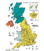
One of our favorite PowerPoint maps is our United Kingdom map. This map which includes England, Wales, Northern Ireland and Scotland is broken down by administrative districts. To get this map we had to contact and license it from Great Britain's Ordnance Survey (OS). I think they are kind of like our US Geological Survey with some Copyright Office thrown in. This map took a long time to draw and I think it ended up pretty well. I enjoy working on these complex map, I often image myself in the areas that I am drawing.
This map is broken down by administrative districts includes surrounding countries, in color with district names and capitals, editable objects. Very detailed map for building sales and marketing territories and regions.
Like all of our maps the administrative districts are individual objects that can be colored and changed so you can build a regional territory map. Add a star for an office, change colors, edit text, pull out sections to highlight a region.
Each map comes already placed into a PowerPoint slide ready for customizing. Names, color, fully editable, PowerPoint map.
bruce
No comments:
Post a Comment