
Friday, May 21, 2010
PowerPoint and Adobe Illustrator USA Editable County Maps Part 1
Wednesday, May 19, 2010
Editable USA County Maps - Massachusetts to Ohio, Part 2

Tuesday, May 18, 2010
USA Editable County PowerPoint and Illustrator Maps Part 3

Thursday, May 13, 2010
Senator Al Franken draws map of USA
Senator Al Franken draws a map of all 50 states from memory during an appearance on Minnesota Public Radio's Midday at the Minnesota State Fair.
It is not uncommon to get a call asking for a map of the 52 US States so it is nice to see one of our newer Senators know just how many states we actually have.
Monday, May 10, 2010
Directory of North America Maps from World of Maps

Including: the United States, Canada, Antiles-Aruba, Argentina, Bahamas, Bermuda, Bolivia, Brazil, Caribbean Islands, and the Cayman Islands. All of these maps come in both editable PowerPoint and Adobe Illustrator format. All elements can be customized for presentations, design projects, education, classroom. All are printable and by just selecting the land and removing the color you have a blank map that can be customized. See all of our editable country maps at www.bjdesign.com
Top Presentation Tips:
An occasional series on handy tips to help you with your presentations
Keep Your Fonts Simple in Your Presentation
Choose a font that is simple and easy to read. If you travel with your presentation choose a font that you know will be on all PCs like Arial, Times New Roman or Verdana, stay away from the fancy ones. One font for headlines and a second for body copy, with the type size fairly large, say 30pt, so everyone can read the slides. Give your font some contrast against the background color to help them stand out.

Friday, May 7, 2010
United Kingdom Editable Printable PowerPoint Maps

We have two United Kingdom maps. One is a general Great Britain map including Scotland, Wales, England, and Northern Ireland. This map also includes Ireland. This maps has a general breakdown of their administrative districts. We also have a much more detailed UK map showing all of the administrative districts or the counties. This map took a long time to draw and a longer time to find a source for. We ended up licensing it from the Ordinance Department in Britain. I think this department is kind of like our USGS department or something similar. But it is a cool map. Both are available at our websites.
If you are traveling to Great Britain, check out Rick Steves's Great Britain book available at Amazon. I watch his PBS travel shows all the time.
Both of these maps are available in PowerPoint and Adobe Illustrator.
Tuesday, May 4, 2010
She Does a Better Job Than Map Quest! - Slate Article
"She Does a Better Job Than Map Quest!"Wonderful hand-drawn maps from firefighters, club-hoppers, Boy Scout dads, grandmothers, and Alexander Calder.
Julia Turner
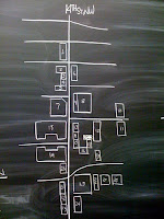
"Last month, I asked Slate readers to send me their hand-drawn maps. The request was part of my series on signs, the tools that professionals use to orient us and direct us from point A to point B. But official signs aren't the only things that help us get around. Since early man first drew on his cave wall—including marks that some scholars argue were maps of local rivers and settlements—we've been sketching out routes to guide one another to the market and to the mountain top. "
Read more of this cool article sent to us by one of our readers at the on line magazine Slate . . .
Earthquake Lists and Maps from the USGS

Here is a fun little earthquake fact. From 1975 - 1995 there were only four states that did not have any earthquakes, florida, Iowa, North Dakota and Wisconsin.
Also included are the Last Earthquakes in each state and country, Seismicity Maps and the really big significant earthquakes. This is as great page for getting all kinds of information on earthquakes. You can also check out all kinds of other info on earthquakes at the USGS Earthquake sites.

World Projections Maps, Mercator, Robinson, Globes

Subscribe to:
Posts (Atom)